Matanuska Glacier, 4 miles wide and 27 miles long, sits alongside the Glenn Highway, the largest glacier accessible by car. I've always wanted to check a glacier walk off my AK bucket list, so north we drove, past Palmer and Sutton, along the windy road lined with aspen and birch trees crisp and golden and burnt orange.
The official National Park Service viewpoint sits at Mile 101 (on the right side if you're heading north). There is a parking fee if you wish to stay longer than half an hour (there are picnic tables and a one-mile hiking trail).
The view from the scenic overlook...Matanuska Glacier, the frozen river of ice
Take note of our clothing in this picture and in the rest of pics below. Even a mile away from the glacier face, it was COLD. We took this snapshot, hurried into the car to get warm and headed to the access point to get a closer look.
Now, glaciers are beautiful, majestic, and simply very very cool (ahem) to look at. But why just look when you can actually touch it...and walk on it...
Glacier Park is a privately-owned swath of land adjacent to the glacier. At Mile 102, there is a dirt road on the right that will take you on a downhill and somewhat bumpy road down.
The road is fairly smooth on the descent.
You need to cross a one-way-at-a-time bridge across the river. You'll have to stop at the gift shop to purchase your access pass. There is a guided tour option for $50/pp. BUT you can go unguided ($15 active military/dependents, $10/13yrs-17yrs, $5/6yrs-12yrs, free for under 6yrsold). They accept credit cards. They also have a decent bathroom (so go there unless you want a porta potty visit later on).
After a little bit more of a drive, we parked at the lot overlooking the face, got out and immediately bundled up in hoodies, fleece, down coats, hats, and gloves. We were also decked out in boots (muddy) and brought our hiking sticks (slick ice).
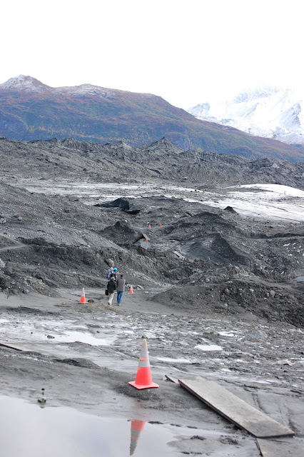
The first part of the 0.5 mile hike was a bit muddy. Of course, this is mud from glacial silt. The majority of the wet portions were fine, but there were some spots that were like quicksand. We were careful to warn the children to stay on the path, marked by orange traffic cones. Especially muddy areas had plywood or steel walking grates to help.
This whole time, we were excited to get to the ice...not realizing we were ALREADY on the glacier itself. We didn't quite get that until we saw this...

Ooooooh
The white part of the glacier (what the kids called the "real part") was fine to walk on, although I'm sure someone would have wiped out if they had chosen to run. The ice crunched under our feet and mini streams of melting ice ran in braids all over the surface.
A stream of meltwater...
...we followed it and it ran into this crevasse about ten feet deep, where you can hear it join another more swiftly flowing larger stream of water under the ice.
We stayed about an hour, exploring a small portion of the area. (We will do more extensive exploration next year when we have more time...and crampons.) The children had fun finding the cracks in the ice and poking their walking sticks in to see how deep they were (a couple were so deep the stick would go all the way in to the handle). We called it a day and headed home.
On the drive back, the beautiful view of King Mountain already blanketed in termination dust.
It's goodbye summer 2012, hello winter for now. (Autumn lasts for about two weeks here it seems.) This, however, does not mean the adventures of the fam are on hold 'till next year. We are determined to explore all the winter has in store for us.
Snowshoeing, cross country skiing, sledding, tubing, igloo building, and so so much more. Stay tuned!


No comments:
Post a Comment